Maps for Mobile Phones
From MMVLWiki
 |  |
 |  |
 |  |
 |  |
 |
| Table of contents |
Maps for J2ME mobile phones
You can download some interactive maps for mobile phones with J2ME/MIDP (Java 2 Micro Edition) as JAR (http://en.wikipedia.org/wiki/JAR_%28file_format%29) files. If you want to download the file using GPRS (http://en.wikipedia.org/wiki/GPRS) you have to use the link to the JAD file instead. Please refer to your mobile-phone's manual on how to install Java programs. E-mail me, if you find a bug in the software.
The size of each software package is mentioned. Note, that temporarily you will need twice as much memory on your mobile, because the JAR-file will only be deleted after installation. You can put comments and submit ratings at getjar.com (http://www.getjar.net/products/4729/VerkehrsnetzMuenchen).
If you want to compile or emulate the software on your PC, you need to download the Java 2 Micro Edition (J2ME) Wireless Toolkit (http://java.sun.com/products/sjwtoolkit/download-2_2.html).
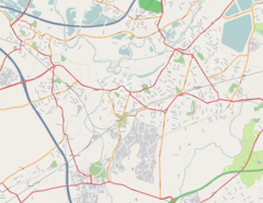
Weybridge example map
The map was taken from openstreetmap.org (http://wiki.openstreetmap.org/index.php/Neat_Stuff) (License: GFDL (http://www.gnu.org/copyleft/fdl.html)).
- MobiNav.jar (http://www.wedesoft.demon.co.uk/downloads/MobiNav.jar) (191 kByte) Java archive
- MobiNav.jad (http://www.wedesoft.demon.co.uk/downloads/MobiNav.jad) description file
- MobiNav.tar.gz (http://www.wedesoft.demon.co.uk/downloads/MobiNav.tar.gz) (176 kByte) source code and map-tiles (license: GPL (http://www.gnu.org/copyleft/gpl.html))
- splitmap.rb (http://www.wedesoft.demon.co.uk/downloads/splitmap.rb) (638 bytes) source code of Ruby script for splitting up an input file into map-tiles (requires HornetsEye)
Note, that for creating map-tiles yourself you need to provide maps for several resolutions (multiresolution pyramid). If you don't have a multiresolution map, you need to scale the input image down to 50% multiple times. You can use the command-line tool convert which is part of ImageMagick (http://www.imagemagick.org/) to do this:
convert map.png -scale 50%% map2.png
convert map2.png -scale 50%% map3.png
convert map3.png -scale 50%% map4.png
convert map4.png -scale 50%% map5.png
convert map5.png -scale 50%% map6.png
Note that each dimension of the last pyramid level (here: map6.png) must not be bigger than the tile size (here: 128)! Afterwards you can create the tiles using the Ruby script splitmap.rb (http://www.wedesoft.demon.co.uk/downloads/splitmap.rb):
./splitmap.rb map.png 128 5
./splitmap.rb map2.png 128 4
./splitmap.rb map3.png 128 3
./splitmap.rb map4.png 128 2
./splitmap.rb map5.png 128 1
./splitmap.rb map6.png 128 0
It is also recommended to compress the resulting map tiles by reducing the number of colours (no dithering!). To do this move the map-tiles into an empty directory and compress the map tiles as follows:
mkdir targets
for i in *.png; do convert $i -depth 8 -colors 32 +dither target/$i; done
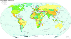
Political world map
The map was taken from the The World Factbook (https://www.cia.gov/library/publications/the-world-factbook/) (License: public domain).
- WorldMap.jar (http://vision.eng.shu.ac.uk/jan/WorldMap.jar) (1370 kByte)
- WorldMap.jad (http://vision.eng.shu.ac.uk/jan/WorldMap.jad)
Visible Earth
The picture was taken from the Visible Earth project (http://visibleearth.nasa.gov/) (License: public domain).
- VEarth.jar (http://vision.eng.shu.ac.uk/jan/VEarth.jar) (1314 kByte)
- VEarth.jad (http://vision.eng.shu.ac.uk/jan/VEarth.jad)
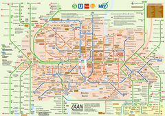
Munich public transportation map
The map was taken from de.wikipedia.org (http://de.wikipedia.org/wiki/Muenchen) (License: GFDL (http://www.gnu.org/copyleft/fdl.html)).
- VerkehrsnetzMuenchen.jar (http://vision.eng.shu.ac.uk/jan/VerkehrsnetzMuenchen.jar) (472 kByte)
- VerkehrsnetzMuenchen.jad (http://vision.eng.shu.ac.uk/jan/VerkehrsnetzMuenchen.jad)
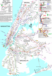
New York City Subway Map
This NYC subway map originated from www.nycsubway.org (http://www.nycsubway.org/maps/spui.html) (License: public domain).
- NYCSub.jar (http://vision.eng.shu.ac.uk/jan/NYCSub.jar) (1657 kByte)
- NYCSub.jad (http://vision.eng.shu.ac.uk/jan/NYCSub.jad)
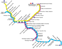
Sheffield Supertram map
The map was taken from en.wikipedia.org (http://en.wikipedia.org/wiki/Sheffield_Supertram) (License: Creative Commons Attribution-ShareAlike 2.0 Canada (http://creativecommons.org/licenses/by-sa/2.0/ca/deed.en_CA))
- Supertram.jar (http://vision.eng.shu.ac.uk/jan/Supertram.jar) (67 kByte)
- Supertram.jad (http://vision.eng.shu.ac.uk/jan/Supertram.jad)
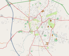
Cambridge multiresolution map
Thanks to the work of the OpenStreetMap (http://www.openstreetmap.org/) community it is now possible to create free multiresolution streetmaps for mobile phones! Free multiresolution maps is a valuable addition to the worlds inventory of free data. The data is subject to the terms and conditions of the Creative Commons Attribution ShareAlike License v. 2.0 (http://creativecommons.org/licenses/by-sa/2.0/).
- Cambridge.jar (http://vision.eng.shu.ac.uk/jan/Cambridge.jar) (1663 kByte)
- Cambridge.jad (http://vision.eng.shu.ac.uk/jan/Cambridge.jad)
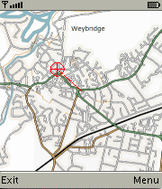
Weybridge multiresolution map
Now there also is a free multiresolution streetmap of Weybridge for J2ME mobile phones. The data is provided by the OpenStreetMap (http://www.openstreetmap.org/) community and subject to the terms and conditions of the Creative Commons Attribution ShareAlike License v. 2.0 (http://creativecommons.org/licenses/by-sa/2.0/).
- Weybridge.jar (http://vision.eng.shu.ac.uk/jan/Weybridge.jar) (1966 kByte)
- Weybridge.jad (http://vision.eng.shu.ac.uk/jan/Weybridge.jad)
Further ideas
- Sky atlas
- Lunar atlas
External Links
- Java ME Toolkit (http://java.sun.com/javame/)
- Maemo-Mapper (http://gnuite.com:8080/nokia770/maemo-mapper/) is a free mobile map software for Nokia 770 (GPL) (hosted at garage.maemo.org (https://garage.maemo.org/projects/maemo-mapper/))
- GpsMid (http://wiki.openstreetmap.org/index.php/GpsMid) J2ME displaying multiresolution streetmaps by rendering OSM vector data
- Free streetmaps for mobile phones (http://home20.inet.tele.dk/skibsvej47/streetmaps.html)
- Download subway maps for iPods (http://www.ipodsubwaymaps.com/)
- OpenStreetMap project (http://www.openstreetmap.org/) now kindly supported by Multimap (http://www.multimap.com/)! Also see OpenStreetMap component overview (http://wiki.openstreetmap.org/index.php/Component_overview#Tiles_and_tile_rendering).
- Openmap software (http://www.openmap.org/)
- German motorways (copyrighted) (http://www.home.fh-karlsruhe.de/~scpa0023/Autobahn.html)
- This software and other mobile phone applications at getjar.com (http://www.getjar.com/)
- WorldMap (http://www.getjar.com/mobile/19008/worldmap/)
- Shopping List (http://www.getjar.com/mobile/4200/shoppinglist)
- FirstPastThePost (http://www.getjar.com/mobile/329/firstpastthepost) is a horce-racing game
- Compass (http://www.getjar.com/mobile/1155/compass) gives the position of sun and moon to determine true north
- London street map (http://www.getjar.com/mobile/3076/londonstreetmap) developed by JTrustN (http://jtrustn.byethost12.com/streetmaps.html)
- ChessChampion (http://www.getjar.com/mobile/17716/chesschampion)
- This software and other applications at softonic.com
- London Tube Map (http://tdhutt.googlepages.com/) (and London Street Map)
- J2ME open source software (http://ngphone.com/j2me/opensource/)
- Yoda decision maker (http://www.panayotis.com/yoda/yoda.html)
- Bomber for J2ME (http://j2mebomber.sourceforge.net/)
- Moon phase calculator for mobile phones (http://www.takechon.net/midp/MoonPhase/)
- Eclipse Calculator (http://www.ecliptomaniacs.com/resources/j2me/)
- Solun'-u (http://www.piecafe.co.uk/solun/usolun2.htm) is a small planetarium (don't confuse sun and moon, they're both yellow)
- Compare mobile phones at gsmarena.com
- NASA's Visible Earth (http://visibleearth.nasa.gov/) project
- benhui.net (http://www.benhui.net/) has some interesting information on how to use Bluetooth
- Tiger Map Server Browser (http://tiger.census.gov/cgi-bin/mapbrowse-tbl)
- Mobile Gmaps (http://www.mgmaps.com/)
- Mobile Google map client (http://www.google.com/gmm/)
- J2MEmap (http://j2memap.landspurg.net/)
- MidpSSH (http://www.xk72.com/midpssh/)
![]()

